When it comes to landscape architecture for large commercial projects, landscape planning technology tools like MapSavvy.com are a landscape architect's best friend.
In simple terms, landscape planning for large public or commercial spaces is an incredibly complex discipline that encompasses a wide array of factors including:
- Land analysis
- Landscape site planning
- Storm water, site drainage & irrigation concerns
- Landscape design
- Landscape management & ongoing maintenance
- Landscape preservation
- Landscape rehabilitation
- Public engagement & societal needs
The good news is that MapSavvy provides critically needed aerial imagery for virtually all stages of landscape architecture for public or large commercial projects.
Landscape Planning Technology Tools Must Provide Historic & Current Imagery
When architects & landscape planners are working on large-scale public or commercial landscaping plans, they need landscape planning technology tools including an affordable source of aerial imagery. MapSavvy provides a powerful aerial imagery solution at an affordable price.
Projects that typically need sophisticated landscape plans & aerial imagery include parks & recreational facilities, streetscapes, public squares, public gardens, hotels & resort properties, corporate business parks, multi-family apartment complexes, senior living complexes, medical campuses, and college & university campuses.
The bottom line is that these types of projects are located on parcels of land that require thoughtful landscaping. One of the main ways to build a comprehensive landscaping plan for these types of facilities is to use aerial imagery at all stages of the project.
MapSavvy Aerial Imagery Is Helpful in All Stages of Comprehensive Landscape Planning
Let's take a quick look at how aerial imagery helps in the various stages of a complex landscape planning project:
Land Analysis — Aerial imagery provides key insights needed for proper analysis of the land, its contours, geographic features, and more.
Landscape Site Planning — Once the land has been analyzed, aerial imagery helps architects & landscape architects make key determinations on where to locate buildings and specific types of landscaping.
Storm Water, Site Drainage & Irrigation — An overhead aerial view of a parcel of land helps architects, landscape architects & engineers determine the natural flow of water over the land, and build in plans to deal with storm water and identify where irrigation is needed.
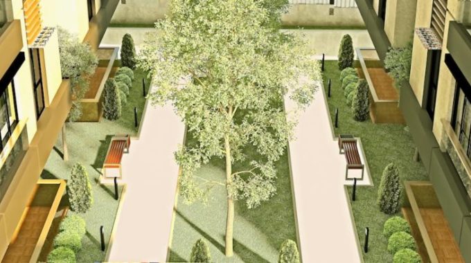
Landscape Design — While landscape design is probably the most fun part of landscaping a large parcel of property, an overhead view (aerial imagery) is still needed to develop a feasible landscape design and renderings.
Landscape Management & Ongoing Maintenance — An often-overlooked aspect of landscaping large parcels is determining how the landscaping will be maintained over time. Aerial imagery from tools like MapSavvy helps planners strategize an ongoing maintenance plan.
Landscape Preservation — More and more governments are requiring that developers honor and preserve open space. Looking at a whole parcel at once, from an overhead perspective, is the fastest, easiest way to see opportunities for meeting open space mandates.
Landscape Rehabilitation — Urban infill projects typically involve transforming existing properties into something new. An overhead view of a property targeted for redevelopment helps architects understand how to make the best use of a property shoe-horned in between other buildings.
Public Engagement — A big part of any public or commercial development involves building support through public engagement. This process requires aerial images to help the public understand the context of the project, where individual elements will be located, and more.
MapSavvy: An Ideal Landscape Planning Technology Tool
When it comes to aerial imagery needed for landscape planning, particularly for complex projects, MapSavvy is a strong choice for architects & landscape architects. Why?
- Affordability: MapSavvy provides aerial imagery at an affordable price — $999 per year for 40,000 WMS requests
- Multiple Layers: straight terrain, terrain with roads, and terrain with roads & labels of notable landmarks
- Historic & Current Imagery: MapSavvy can provide before-after aerial images
- Ease of Use: MapSavvy interfaces with many different GIS platforms
If you're involved with landscaping for large public & commercial projects, you will need aerial images. Give MapSavvy from OnTerra Systems a try. We offer a free 14-day trial, or contact us for more information.