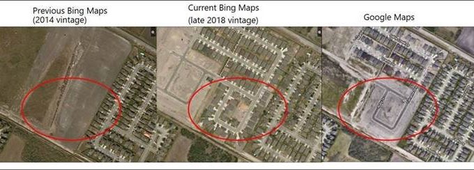
For business, government & research applications that make use of aerial imagery, it's often critically important to have new Bing Maps imagery for the most accurate representations of an area. Customers asked, and the Bing Maps team listened: Bing Maps invested heavily in expanding and refreshing their aerial imagery, including the introduction of brand-new 30cm imagery for 42 U.S. cities.
MapSavvy Now Offers an Additional Option: New Bing Maps Imagery from 2019
As a result of updates from Bing Maps, MapSavvy offers multiple options for aerial imagery, including:
- Historic imagery (older high-resolution imagery important for "before" comparisons)
- Imagery with multiple layer options (basic imagery, imagery with roads & imagery with key landmarks labeled)
- New 2019 imagery (30cm aerial imagery taken in 2019 for 42 US cities, with more coming online throughout 2019)
New Bing Maps Imagery Updates Include 166K Square Kilometers of Updated Images
The Bing Maps team worked to bring 166,000 square kilometers of refreshed, high-resolution imagery online by the end of summer 2019. After that, they released between 8,000–13,000 square kilometers of updated aerial imagery every week for the rest of 2019, and into 2020.
It's no surprise that the new, refreshed Bing Maps imagery being introduced starts with metropolitan areas and densely populated areas.
The cities for which new Bing Maps imagery updates became available by the end of May 2019 included: Abilene TX, Albuquerque NM, Austin TX, Boise ID, Boulder CO, Brighton MI, Carson City NV, Charleston WV, Clarksville TN, Colorado Springs CO, Dallas TX, Denver CO, Dover DE, Fayetteville NC, Fort Wayne IN, Gainesville FL, Greenville SC, Idaho Falls ID, Indianapolis IN, Jacksonville Beach FL, Kennewick WA, Killeen TX, Lafayette IN, Lafayette LA, Los Angeles CA, Lubbock TX, Lynchburg VA, Malibu CA, Medford OR, New Haven CT, Norfolk VA, Omaha NE, Peoria IL, Phoenix AZ, Reno NV, Salem OR, San Diego CA, Santa Fe NM, Santa Rosa CA, South Bend IN, Springfield IL, and Waco TX.
MapSavvy Offers Access to New Bing Maps Imagery
Since MapSavvy is based on Bing Maps, MapSavvy users gain access to all this refreshed 30cm Bing Maps imagery. What's more, MapSavvy offers access to this new Bing Maps imagery for a fraction of the cost of other aerial imagery services. Users can sign up for MapSavvy for a flat fee of $999 per year, with 40,000 WMS requests available for this base price. (More is available if needed, for a modest additional price.)
OnTerra Systems chose to base MapSavvy on Bing Maps for two main reasons: Bing Maps was far more affordable than Google Maps, and Bing Maps was investing heavily in its mapping — which means MapSavvy users can gain access to new imagery for a very competitive price point.
If you need access to new Bing Maps imagery at an affordable price, give MapSavvy from OnTerra Systems a try. We offer a free 14-day trial, or contact us for more information.