OnTerra Systems today announced that its MapSavvy WMS now has Google Maps layers, along with…
Quick Tips on Aerial Maps Options in the MapSavvy WMS
In late 2017, we announced that a new, improved MapSavvy aerial maps imagery service that offers users the option of using original Bing Maps images or new, updated Bing Maps images. This article provides some quick tips and advice on which imagery option to use based on your industry and how you’re using the images.
Highlights of MapSavvy Updates in Late 2017
As a quick memory refresher, the new and improved MapSavvy offers multiple imagery options. MapSavvy offers users the ability to access all the new, updated imagery from the Bing Maps update that occurred in 2017. The caveat is that the new Bing Maps imagery features a lower resolution than the original imagery.
We found that some MapSavvy users preferred to continue using the original imagery from Bing Maps.
So the new MapSavvy version introduced in November 2017 features the ability for users to choose to continue using the original Bing Maps imagery, or to switch to the new updated Bing Maps imagery.
With that in mind, we’re providing some quick tips on which versions of these aerial maps to access based on how you’re using the images and your priorities for presenting aerial maps as part of your job.
MapSavvy Quick Tips: Which Aerial Maps Option Is Best For You?
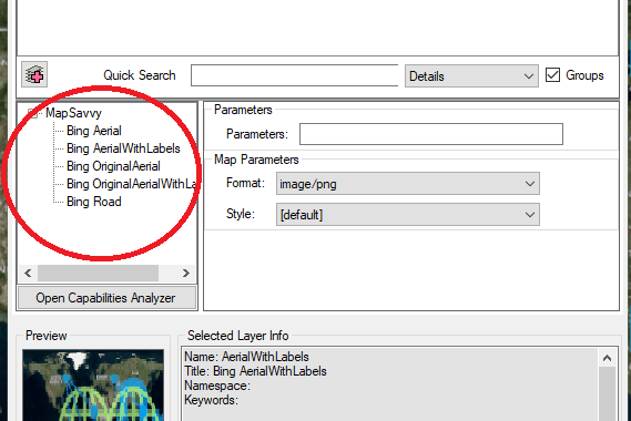
MapSavvy offers the ability to access the following:
Original Aerial Maps from Bing = High resolution, but some imagery may be out of date
New Aerial Maps from Bing = Lower resolution, but with updated imagery
So how do you choose which aerial imagery is best for your needs?
Here are some simple guidelines:
- Professional Presentation: I need to make a presentation that will include aerial maps and I need it to look super crisp and clear – Choose original Bing imagery (pre-2017 updates)
- Architecture: I am presenting a proposal for a building site and I need to show the most up-to-date context of surrounding structures – Choose updated Bing imagery mode (2017 updates)
- Pipeline Development: I am presenting a proposal for a pipeline, and I need to show the most up-to-date landscape of where the pipeline is located in relation to nearby housing developments – Choose updated Bing imagery mode (2017 updates)
- Law Enforcement: We are working to solve a crime and need to see patterns of where the crimes are occurring right now – Choose updated Bing imagery mode (2017 updates)
When choosing what type of aerial maps are best for your application when using MapSavvy, here are some general rules of thumb:
- If you need the most crisp, high-resolution aerial maps images, and the area you’re depicting hasn’t seen a lot of change, use the original Bing Maps images mode.
- If you need to show the latest landscape or urban area and it has seen change that will affect what you are presenting, use the new 2017 Bing Maps update mode.
To access the original and new imagery layers in MapSavvy, may sure you update your WMS URL to wms2.mapsavvy.com
e.g. http://wms2.mapsavvy.com/WMSService.svc/<yourtoken>/WMSLatLon
If you’re already using MapSavvy, you’re already aware that this aerial maps service costs half of what other aerial imagery services are charging. If you’re not yet using MapSavvy, give it a try with our Free Trial, or visit MapSavvy.com for more information.
Related Posts