When it comes to urban development, it’s helpful to make use of WMS providers with…
MapSavvy: An Affordable, Effective Hurricane Damage Assessment Tool
As we enter this year’s hurricane season, it’s helpful to know about MapSavvy as an affordable, effective hurricane damage assessment tool.
How Does MapSavvy Help Assess Hurricane Damage?
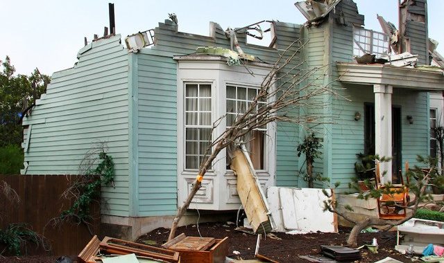
When a hurricane roars through an area, whether it’s wild land or an urban corridor, the damage that’s left behind must be assessed for emergency response, for insurance purposes, and for assessing geographic changes that occurred as a result of the hurricane. In all these instances, MapSavvy.com can help…and for a fraction of the cost of many other sources of aerial imagery.
So, let’s take a look at how MapSavvy helps assess the damage in the aftermath of a hurricane.
When a hurricane powers through an area, it can leave changes that last for decades, as well as costing millions or billions of dollars for rebuilding homes, buildings, power grids, and transportation infrastructure.
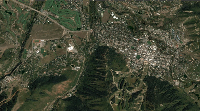
MapSavvy provides the “Before” images for comparison with new images taken by satellite or drone following a destructive storm. By providing affordable images that can be compared to “After” images of an area hit by a storm, emergency response planners & city administrators can make more thoughtful & informed decisions to cope with the aftermath of a storm.
Hurricane Damage Assessment Step 1: Emergency Response
Obviously the first step in hurricane damage assessment is for the purposes of emergency response. Emergency management departments must be able to get fast assessments of damage, people who may be trapped, and plan rescue operations accordingly.
Part of that emergency response effort will involve a comparison of what WAS there in terms of roads, bridges, rivers, what’s been washed out, and how to deal with it for the most effective emergency response.
In this case, MapSavvy can quickly provide affordable “Before” images for emergency response managers to compare with new aerial imagery. Once new photos of the hard-hit area have been compared with “Before” images from MapSavvy, emergency response planners can kick into gear with plans for rescues, emergency housing for people rendered homeless by the storm, and more.
Hurricane Damage Assessment Step 2: Public Infrastructure Damage Assessment
While the emergency response teams are assessing damage, rescue needs, and planning their attack, municipal, state, and federal emergency response professionals will be assessing how the public infrastructure has been affected by the hurricane, and how to stage the most-needed repairs to ensure public safety.
In this instance, city planners & emergency response teams can be assessing what’s happened to public infrastructure such as roads, bridges, and power infrastructure.
A key tool in this assessment process is again to compare “Before” images from MapSavvy with aerial images taken by satellite or drone after the hurricane has passed through, and then compare them. By using this combination of aerial images, city planners & power grid managers can assess the areas with the most damage and use that information to build emergency plans for repairs to public infrastructure.
Hurricane Damage Assessment Step 3: Emergency Housing
Once emergency response has addressed immediate dangers, and public infrastructure repairs are underway, the long-term planning for emergency housing kicks in. Staffers from federal and state agencies are deployed to plan for housing people when homes & buildings have been damaged to the point that they’re unlivable.
Before aerial imagery from MapSavvy vs. After aerial imagery is key to assessing areas that will need federal & state emergency services such as emergency housing.
Hurricane Damage Assessment Step 4: Insurance Industry Involvement
The highest priority activities will revolve around emergency response to save lives & property, and then public infrastructure repairs. After the emergency response efforts are well underway, then the insurance industry needs information to assess damage, process claims, and help property owners get back on their feet & repair damage.
Hurricane Damage Assessment Step 5: Research & Scientific Study
Once the practicalities of dealing with emergency response, public infrastructure repairs, and getting the insurance industry involved are underway, it’s time for the scientists and researchers to get involved to assess the storm’s intensity, patterns of destruction, changes in geography, and more. It’s common for these research teams studying the aftermath of a hurricane to be on tight budgets. That’s when MapSavvy is helpful in providing some of the most affordable sources of “Before” aerial imagery needed for the scientific comparisons with images taken after the hurricane.
Bottom line: MapSavvy is one of the most affordable, effective sources of “Before” aerial imagery that proves invaluable in the multiple stages of hurricane damage assessment. MapSavvy is ideal for emergency response departments, city planners, federal & state emergency response organizations, insurance adjusters & planners, and the scientists who study the storm once the basic needs of rescue, repair & emergency housing have been addressed.
MapSavvy provide one of the most flexible & cost-effective sources of aerial imagery needed for the process of hurricane damage assessment. Many aerial imagery services charge thousands of dollars per year, and often for limited geographic scope of web images.MapSavvy.com costs just $500 as a starting point, and is a critical tool in helping communities and individuals pick up the pieces after a major storm.
Interested in learning more about how MapSavvy can be used in hurricane damage assessment? Visit: www.MapSavvy.com, or try our Free, 14-day trial.
Related Posts