When it comes to urban development, it’s helpful to make use of WMS providers with…
MapSavvy Offers New 30cm Bing Maps Imagery from 2019
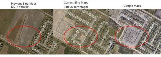
For business, government & research applications that make use of aerial imagery, it’s often critically important to have new Bing Maps imagery for the most accurate representations of an area. Customers asked, and the Bing Maps team listened: Bing Maps is investing heavily in expanding and refreshing their aerial imagery, including the introduction of brand, new 30cm imagery for 42 U.S. cities.
MapSavvy Now Offers An Additional Option: New Bing Maps Imagery from 2019
As a result of updates from Bing Maps, MapSavvy now offers multiple options for aerial imagery, including:
• Historic imagery (older high-resolution imagery important for “before” comparisons);
• Imagery with multiple layer options (basic imagery, imagery with roads & imagery with key landmarks labeled)
• New 2019 imagery (30cm aerial imagery taken in 2019 for 42 US cities, with more coming on line throughout 2019).
New Bing Maps Imagery Updates To Include 166K Square Kilometers of Updates Images
The Bing Maps team is hard at work to bring 166,000 square kilometers of refreshed, high-resolution imagery on line by the end of summer 2019. After that, they’ll be releasing between 8,000-13,000 square kilometers of updated aerial imagery every week for the rest of 2019, and into 2020.
It’s no surprise that the new, refreshed Bing Maps imagery being introduced starts with metropolitan areas and densely populated areas.
Here’s a list of the cities for which new Bing Maps imagery updates will be available by the end of May 2019.
ABILENE, Texas
ALBUQUERQUE, New Mexico
AUSTIN, Texas
BOISE, Idaho
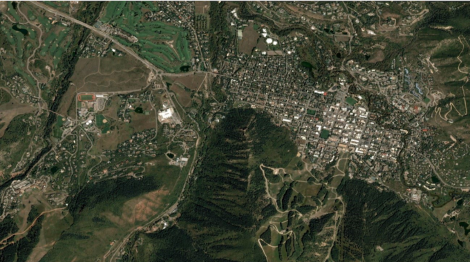
BOULDER, Colorado
BRIGHTON, Michigan
CARSON CITY, Nevada
CHARLESTON, West Virginia
CLARKSVILLE, Tennessee
COLORADO SPRINGS, Colorado
DALLAS, Texas
DENVER, Colorado
DOVER, Delaware
FAYETTEVILLE, North Carolina
FORT WAYNE, Indiana
GAINESVILLE, Florida
GREENVILLE, South Carolina
IDAHO FALLS, Idaho
INDIANAPOLIS, Indiana
JACKSONVILLE BEACH, Florida
KENNEWICK, Washington
KILLEEN, Texas
LAFAYETTE, Indiana
LAFAYETTE, Louisiana
LOS ANGELES, California
LUBBOCK, Texas
LYNCHBURG, Virginia
MALIBU, California
MEDFORD, Oregon
NEW HAVEN, Connecticut
NORFOLK, Virginia
OMAHA, Nebraska
PEORIA, Illinois
PHOENIX, Arizona
RENO, Nevada
SALEM, Oregon
SAN DIEGO, California
SANTA FE, New Mexico
SANTA ROSA, California
SOUTH BEND, Indiana
SPRINGFIELD, Illinois
WACO, Texas
MapSavvy Offers Access to New Bing Maps Imagery
Since MapSavvy is based on Bings Maps, MapSavvy users will gain access to all this new, refreshed 30cm Bing Maps imagery shot in 2019. What’s more, MapSavvy offers access to this new Bing Maps imagery for a FRACTION of the cost of other aerial imagery services. Users can sign up for MapSavvy for a flat fee of $500/year, with 20,000 image transactions available for this base price. (More is available if needed, and for a modest additional price.)
“The OnTerra Systems team is really pleased with the heavy investments Bing Maps is making to provide new aerial imagery shot in 2019,” said Steve Milroy, OnTerra Systems president. “We chose to base MapSavvy on Bing Maps for two main reasons. One, Bing Maps is far more affordable than Google Maps. Second, Bing Maps is investing heavily in its mapping, which means MapSavvy users can gain access to this new imagery for the lowest price point in this market.”
If you need access to new Bing Maps imagery at an affordable price, give MapSavvy from USA-based OnTerra Systems a try. We offer a Free, 14-day Trial or Contact Us for more information.
Related Posts