When it comes to urban development, it’s helpful to make use of WMS providers with…
How The MapSavvy Web Mapping Service Functions As A Powerful Humanitarian Aid Planning Tool
While satellite & aerial web maps have many uses in business, government & research, web map services like MapSavvy also serve as a power humanitarian aid planning tool in the aftermath of natural or man-made disasters.
MapSavvy Works As A Humanitarian Aid Planning Tool for All 3 Phases
Humanitarian aid is a complex process that can span cities, regions, countries, and multiple countries, as well as multiple types of needs for people affected by natural or man-made disasters. The good news is that MapSavvy provides needed visual information that helps in the three main phases of humanitarian aid planning.
Regardless of whether a Cat 5 hurricane, epic flood, or political unrest, coup, or genocide campaign is the source of the disaster, there are still three main phases of dealing with the situation. The three main facets of humanitarian aid planning include:
- Needs Assessment
- Strategic Response Planning
- Strategic Response Monitoring
Humanitarian Aid Planning Phase 1: Needs Assessment
In this phase, humanitarian aid coordinators need to assess:
- What’s specifically has happened?
- Do people need to be rescued?
- Do people need food, shelter, or medical care?
- Do people need protection from violence?
- Has infrastructure been damaged or destroyed?
- Is the power out?
- Are water processing facilities off-line?
- Do people need to be moved from one area to another, and how many need to be transported and where?
- Are roads and bridges still in good shape, or are they blocked, washed out, structurally damaged, or destroyed?
- What’s the landscape in the affected area? Are there geographic features that help or hinder humanitarian aid efforts?
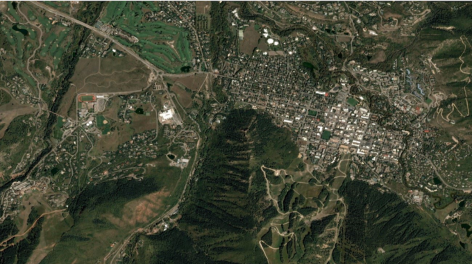
MapSavvy is particularly helpful in the humanitarian aid assessment phase. By providing affordable web map images from the past, humanitarian aid coordinators can compare historic images of an aerial with real-time satellite or drone footage to assess the damage.
Humanitarian Aid Planning Phase 2: Strategic Response Planning
In the strategic response phase, humanitarian aid planners work to develop a set of overriding goals tied to specific action items. Then, they chunk the tasks & actions down into “clusters” so it’s easier to manage and deploy.
MapSavvy is helpful at this stage, because this is the stage where humanitarian aid workers are involved in developing plans and costing them out. MapSavvy helps the planning & costing process by providing “Before” images that help determine the magnitude of the damage, plans, and what’s needed to resolve the situation. By comparing “Before” images of the affected area, or images of an area targeted for re-locating affected people, planners can understand infrastructure that’s already there or that’s needed – and then develop plans and costs.
Humanitarian Aid Planning Phase 3: Response Monitoring
The final component of any humanitarian response plan is to monitor progress and put in place any changes that may be needed. In response monitoring, Before-After images of a distressed area can speak volumes about how the humanitarian program is progressing. When humanitarian aid teams are able to showing progress or the magnitude of the problem visually, it can galvanize public awareness and lead the way to additional support.
MapSavvy provides images taken in 2017 and also historical images taken years ago. By having this library of 2017 images and historical images, humanitarian aid strategists can show levels of destruction, geographic challenges, and build support for additional aid.
The bottom line is that humanitarian aid programs are needed with increasing frequency, thanks to an increasing number of devastating hurricanes, typhoons, and floods, along with unrest in the world that leads to massive migrations of people fleeing a war zone. MapSavvy is a powerful humanitarian aid planning tool that helps pick up the pieces after natural or man-made disasters.
Want to learn tips on how to buy satellite or aerial imagery? Access the MapSavvy Web Mapping Buying Guide.
Interested in learning more about MapSavvy and giving it a test drive? Visit: www.MapSavvy.com, or try our Free, 14-day trial.
Related Posts